50. Bird, P. (2003) An updated digital model of plate boundaries, Geochemistry Geophysics Geosystems, 4(3), 1027, doi:10.1029/2001GC000252.
Abstract. A global set of present plate boundaries on the Earth is presented in digital form. Most come from sources in the literature. A few boundaries are newly interpreted from topography, volcanism, and/or seismicity, taking into account relative plate velocities from magnetic anomalies, moment tensor solutions, and/or geodesy. In addition to the 14 large plates whose motion was described by the NUVEL-1A poles (Africa, Antarctica, Arabia, Australia, Caribbean, Cocos, Eurasia, India, Juan de Fuca, Nazca, North America, Pacific, Philippine Sea, South America), model PB2002 includes 38 small plates (Okhotsk, Amur, Yangtze, Okinawa, Sunda, Burma, Molucca Sea, Banda Sea, Timor, Birds Head, Maoke, Caroline, Mariana, North Bismarck, Manus, South Bismarck, Solomon Sea, Woodlark, New Hebrides, Conway Reef, Balmoral Reef, Futuna, Niuafo'ou, Tonga, Kermadec, Rivera, Galapagos, Easter, Juan Fernandez, Panama, North Andes, Altiplano, Shetland, Scotia, Sandwich, Aegean Sea, Anatolia, Somalia), for a total of 52 plates. No attempt is made to divide the Alps-Persia-Tibet mountain belt, the Philippine Islands, the Peruvian Andes, the Sierras Pampeanas, or the California-Nevada zone of dextral transtension into plates; instead, they are designated as "orogens" in which this plate model is not expected to be accurate. The cumulative-number/area distribution for this model follows a power law for plates with areas between 0.002 and 1 steradian. Departure from this scaling at the small-plate end suggests that future work is very likely to define more very small plates within the orogens. The model is presented in four digital files: a set of plate boundary segments; a set of plate outlines; a set of outlines of the orogens; and a table of characteristics of each digitization step along plate boundaries, including estimated relative velocity vector and classification into one of 7 types (continental convergence zone, continental transform fault, continental rift, oceanic spreading ridge, oceanic transform fault, oceanic convergent boundary, subduction zone). Total length, mean velocity, and total rate of area production/destruction are computed for each class; the global rate of area production and destruction is 0.108 m2/s, which is higher than in previous models because of the incorporation of back-arc spreading.
P.S. Now that the Banda Aceh earthquake has focussed attention on the area around the Andaman Sea, you may see reproductions of these plate boundaries on regional maps by others. In some cases, the grid pattern for the “Persia-Tibet-Burma orogen” has been omitted. This is unfortunate, because the grid is a warning that plate boundaries in the gridded region are oversimplified and not to be taken literally. In particular, the curved fault under the Irrawaddy delta, separating the BU and IN plates, may not exist. It is merely one hypothetical solution to the kinematic problem of how to accomodate the relative rotation of these two plates. (Of course, any other solution is likely to imply a similar seismic hazard.)
N.B. For further analysis of the exponent and significance of the power-law distribution of plate sizes, see: Sornette, D., and V. Pisarenko, Fractal plate tectonics, Geophys. Res. Lett., 30(3), 1105, doi:10.1029/2002GL015043, 2003. P. Bird, 2003.02.14
Entire paper as a 52-page color .pdf file (13 MB; does not include ASCII data files or wall map)
The ASCII data files (digitized plate boundaries, via FTP)
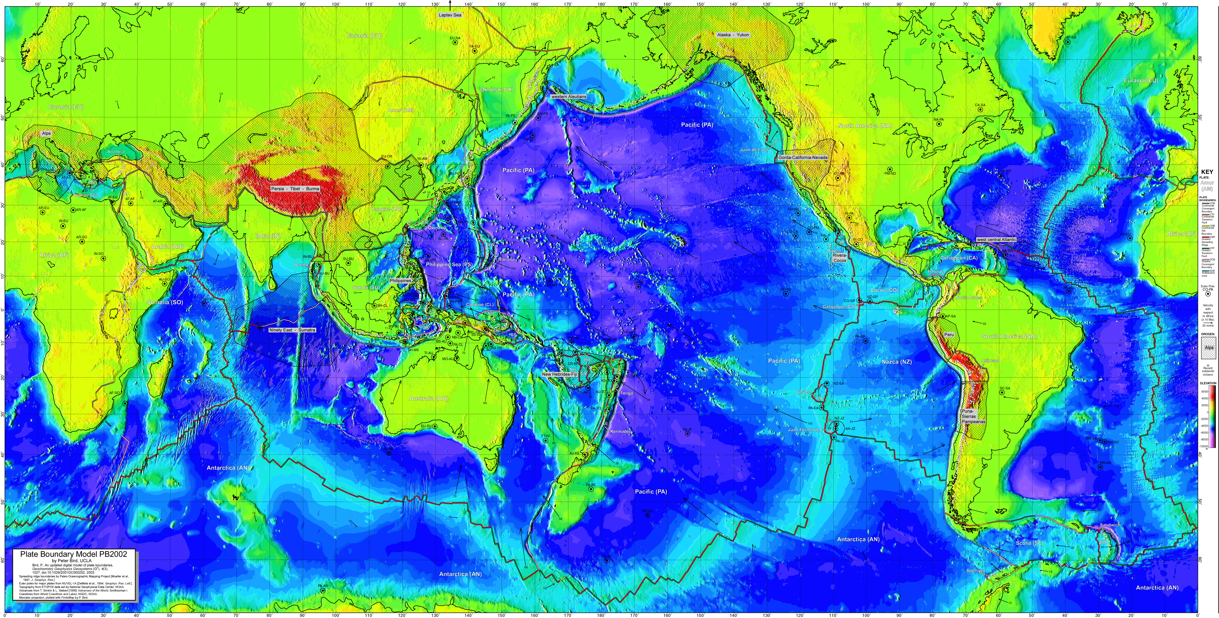
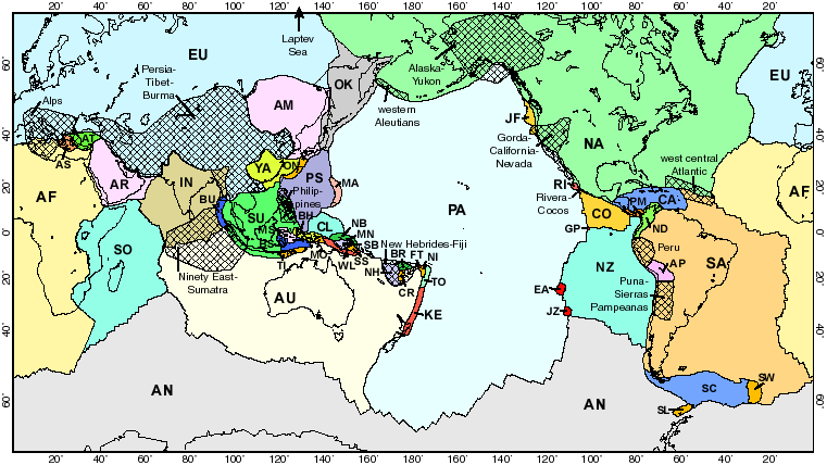
Figure 1. The 52 plates of model PB2002 are shown with contrasting colors. Two-letter plate identifiers are explained in Table 1. The 13 cross-hatched areas are "orogens" in which an Eulerian plate model is not expected to be accurate. Labels of small plates and orogens are offset (with leader lines) for clarity. Mercator projection.
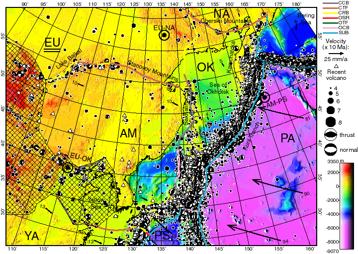
Figure 2. Boundaries of the Okhotsk (OK) and Amur (AM) plates. Surrounding plates include Eurasia (EU), North America (NA), Pacific (PA), Philippine Sea (PS), and Yangtze (YA). Boundary types are: CCB continental convergent boundary, CTF continental transform fault, CRB continental rift boundary, OSR oceanic spreading ridge, OTF oceanic transform fault, OCB oceanic convergent boundary, SUB subduction zone. Cross-hatched regions are orogens. Color shows topography from ETOPO5. Solid dots are shallow (< 70 km) hypocenters from ISC catalog, 1964-1991; beachballs are lower-hemisphere projections of douple-couple parts of moment tensors of shallow centroids from Harvard CMT catalog, 1977-1998. White triangles are subaerial Recent volcanoes from Simkin and Siebert [1995]. Black vectors give model velocities (with numbers in mm/a) relative to plate whose identifier is underlined. Black circles are locations of Euler poles, about which the first-named plate rotates counterclockwise relative to the second. Oblique Mercator projection with great circle passing E-W through (135° E, 48° N).
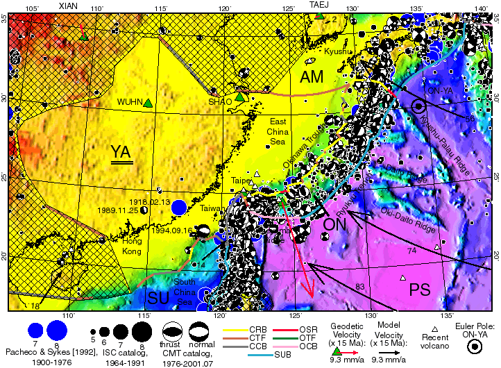
Figure 3. Boundaries (heavy colored lines) of the Yangtze (YA) and Okinawa (ON) plates. Surrounding plates include Sunda (SU), Philippine Sea (PS), and Amur (AM). Conventions as in Figure 2. Additional epicenters in blue (mw > 7, 1900-1976) are from Pacheco and Sykes [1992]. Geodetic velocity of Ishigaki Island from Kato et al. [1998] is plotted relative to YA. Oblique Mercator projection with great circle passing E-W through (127° E, 27° N).
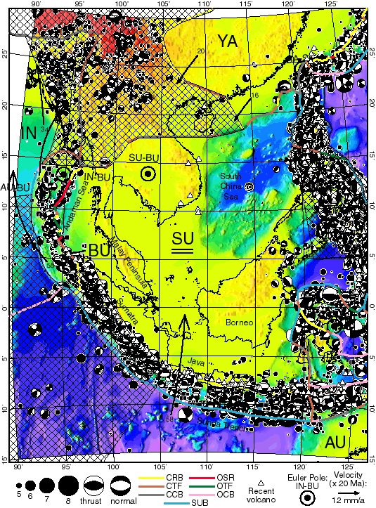
Figure 4. Boundaries (heavy colored lines) of the Sunda (SU) and Burma (BU) plates; surrounding plates include India (IN), Australia (AU), and Yangtze (YA). An orogen and several small plates east of SU are better represented in Figures 5 and 6, respectively. The southeastern prong of Eurasia (EU) is not stable but is part of the Persia-Tibet-Burma orogen. Cross-hatching in southwest shows Ninety East-Sumatra orogen. Conventions as in Figure 2. Transverse Mercator projection on meridian 108° E.
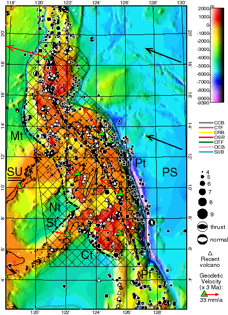
Figure 5. The Philippines orogen (black outline with cross-hatching) surrounds the Philippine Sea (PS) - Sunda (SU) convergent plate boundary (heavy colored lines). Important active faults plotted with heavy dashed lines: Philippine trench Pt, Manila trench Mt, Negros trench Nt, Sulu trench St, Cotobato trench Ct, Philippine fault Pf. Geodetic velocities from Rangin et al. [1999] are plotted relative to SU. Other conventions as in Figure 2. Transverse Mercator projection on meridian 124° E.
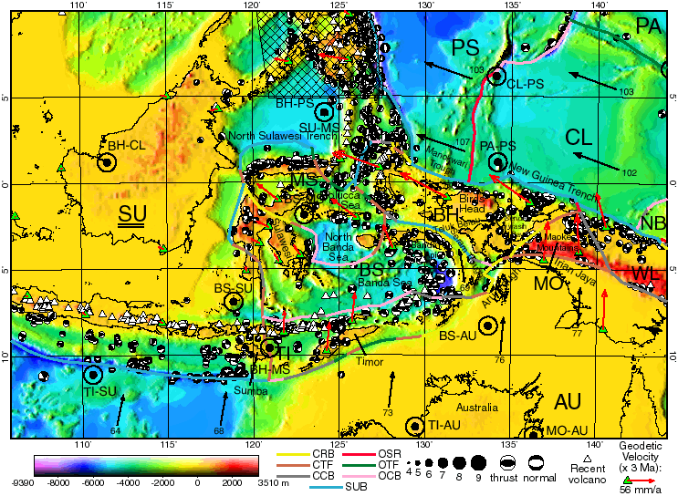
Figure 6. Boundaries (heavy colored lines) of the Molucca Sea (MS), Banda Sea (BS), Timor (TI), Birds Head (BH), and Maoke (MO) plates. Surrounding plates include Sunda (SU), Australia (AU), Woodlark (WL), North Bismarck (NB), Caroline (CL), and Philippine Sea (PS). Conventions as in Figure 2, except ISC epicenters are omitted for clarity. Geodetic velocities from Puntodewo et al. [1994] and Rangin et al. [1999] are plotted relative to SU. Oblique Mercator projection with great circle passing E-W through (125° E, 2.5° S).
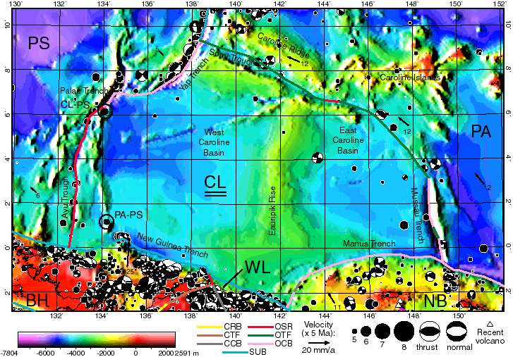
Figure 7. Boundaries (heavy colored lines) of the Caroline (CL) plate. Surrounding plates include Philippine Sea (PS), Birds Head (BH), Woodlark (WL), North Bismarck (NB) and Pacific (PA). Conventions as in Figure 2. Oblique Mercator projection with great circle passing E-W through (141° E, 4° N).
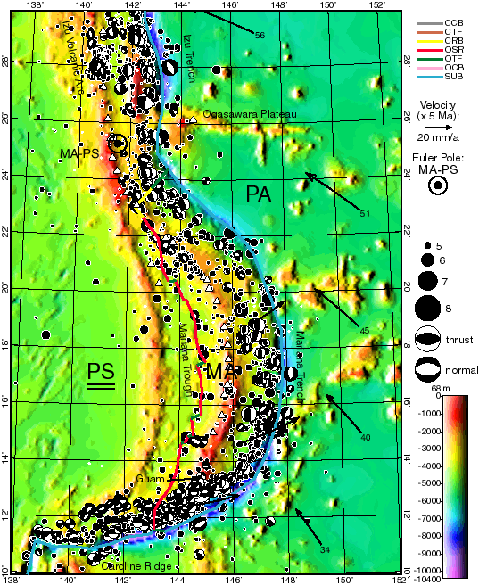
Figure 8. Boundaries (heavy colored lines) of the Mariana (MA) plate, lying between the Philippine Sea (PS) and Pacific (PA) plates. Conventions as in Figure 2. Transverse Mercator projection on meridian 145° E.
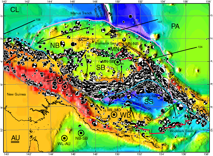
Figure 9. Boundaries (heavy colored lines) of the North Bismarck (NB), Manus (MN), South Bismarck (SB), Solomon Sea (SS) and Woodlark (WL) plates. Surrounding plates include Australia (AU), Caroline (CL), and Pacific (PA). Conventions as in Figure 2. Oblique Mercator projection with great circle passing E-W through (149° E, 5.5° S).
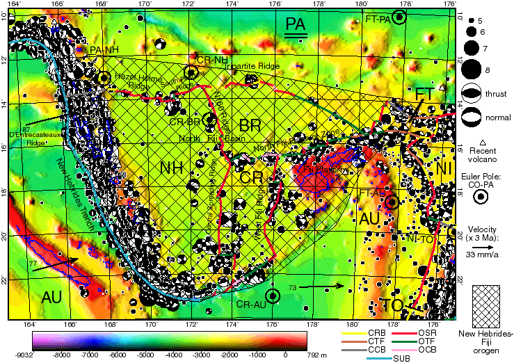
Figure 10. Boundaries (heavy colored lines) of the New Hebrides (NH), Balmoral Reef (BR), Conway Reef (CR), and Futuna (FT) plates. All are included in the New Hebrides-Fiji orogen because of evidence that they may be deforming rapidly. Surrounding plates are Australia (AU), Tonga (TO), Niuafo'ou (NI), and Pacific (PA). Conventions as in Figure 2, except coastlines are blue. Oblique Mercator projection on great circle passing E-W through (17° S, 174° E).
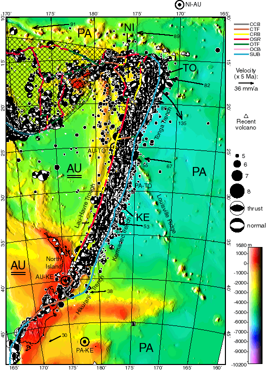
Figure 11. Boundaries (heavy colored lines) of the Tonga plate (TO), Kermadec plate (KE), and Niuafo'ou plate (NI). Surrounding large plates are Australia (AU) and Pacific (PA). Cross-hatched region is the New Hebrides-Fiji orogen (see Figure 10). Conventions as in Figure 2. Transverse Mercator projection on meridian 177.5° W.
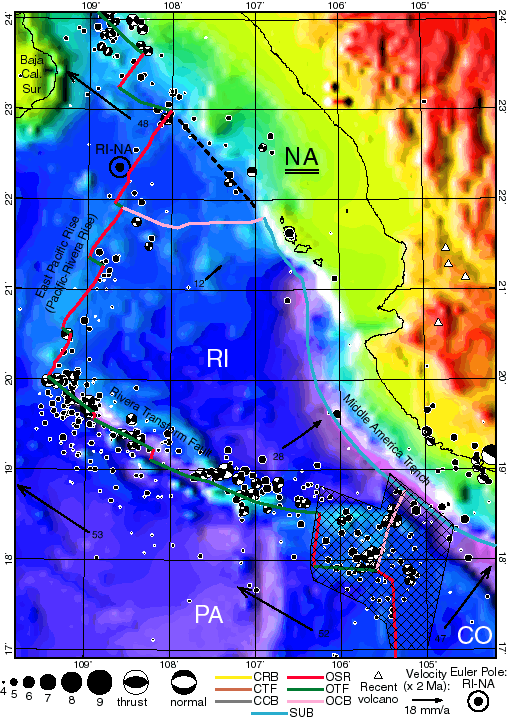
Figure 12. Boundaries (heavy colored lines) of the Rivera (RI) plate, surrounded by North America (NA), Pacific (PA), and Cocos (CO) plates. Cross-hatched area is the Rivera-Cocos orogen. Dashed black line shows former RI-NA boundary. Other conventions as in Figure 2. At the large scale of this map, errors in hypocenter and centroid locations are not negligible.
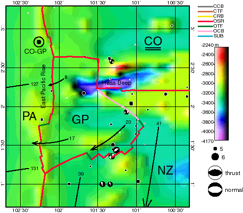
Figure 13. Boundaries (heavy colored lines) of the Galapagos (GP) plate, surrounded by Pacific (PA), Cocos (CO), and Nazca (NZ) plates. Conventions as in Figure 2. At the large scale of this map, errors in hypocenter and centroid locations are not negligible, and the limited resolution of topographic model ETOPO5 is apparent. High-resolution bathymetry may be seen in Lonsdale [1988].
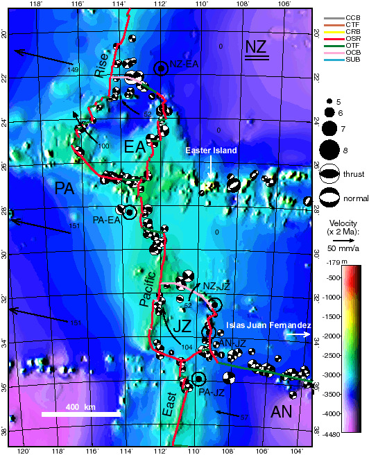
Figure 14. Plate boundaries (heavy colored lines) of the Easter (EA) and Juan Fernandez (JZ) plates. Surrounding plates are Pacific (PA), Antarctica (AN), and Nazca (NZ). Conventions as in Figure 2. Transverse Mercator projection on meridian 112° W.
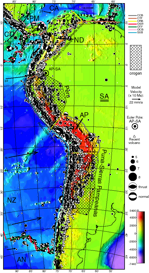
Figure 15. Boundaries (heavy colored lines) of the Panama (PM), North Andes (ND), and Altiplano (AP) plates. Surrounding plates are Antarctica (AN), South America (SA), Caribbean (CA), Cocos (CO), and Nazca (NZ). Cross-hatched areas are the Peru and Puna-Sierras Pampeanas orogens. Conventions as in Figure 2. Transverse Mercator projection on meridian 72.5° W.
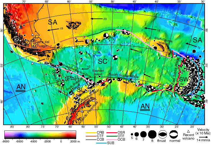
Figure 16. Boundaries (heavy colored lines) of the Shetland (SL), Scotia (SC), and Sandwich (SW) plates. Surrounding plates are Antarctica (AN) and South America (SA). The former Phoenix plate [(Ph); dashed black line] has now merged with AN. Other conventions as in Figure 2. Oblique Mercator projection with great circle passing E-W through (52° W, 58° S).
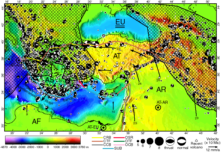
Figure 17. Boundaries (heavy colored lines) of the Aegean Sea (AS) and Anatolia (AT) plates, which are surrounded by the Africa (AF), Arabia (AR), and Eurasia (EU) plates. The two cross-hatched regions are the Alps and Persia-Tibet-Burma orogens in the west and east, respectively. Conventions as in Figure 2. Oblique Mercator projection with great circle passing E-W through (33.5° E, 38° N).
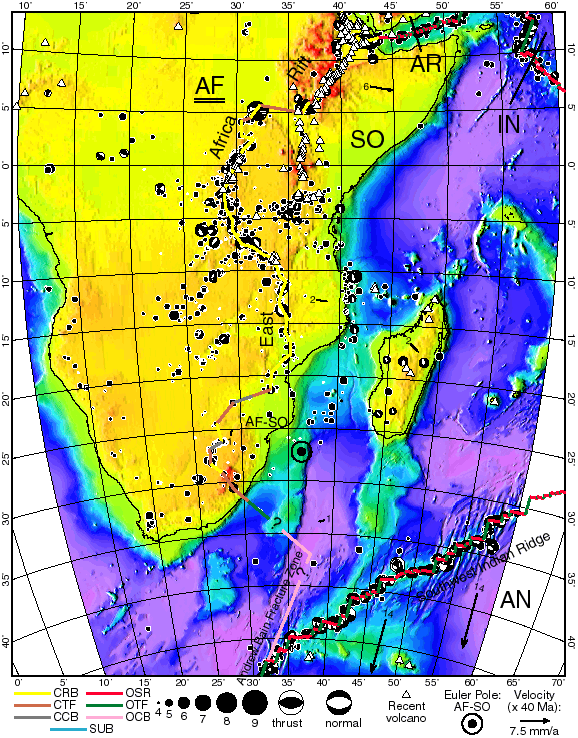
Figure 18. Western boundaries (heavy colored lines) of the Somalia (SO) plate, surrounded by Africa (AF), Antarctica (AN), India (IN), and Arabia (AR). Conventions as in Figure 2. Southernmost part of AF-SO boundary is from Lemaux et al. [2002], but portions in 22° -42° S are conjectural. Transverse Mercator projection on meridian 35° E.
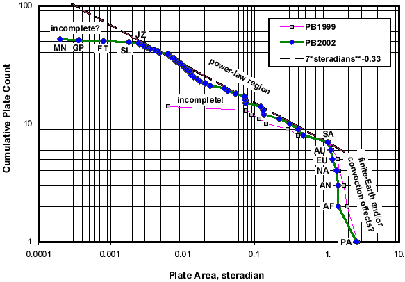
Figure 19. Number of plates exceeding a given area, plotted as a function of area. Curve PB2002 is for the present model, and curve PB1999 is for the previous 14-plate model of Bird et al. [2002]. The relatively steady slope of the PB2002 curve for plate areas between 0.002 and 1 steradian suggests a power law relationship between the number of plates and their minimum size. Just as flattening of the PB1999 curve was an artifact of model incompleteness, flattening of the PB2002 curve at 0.002 probably indicates that there are many more small plates below this size not recognized in the model. Very large plates are limited in their area because of the finite area of the Earth, and perhaps also by mantle convection tractions.